| Year | Total | Urbanized areas | Areas occupied by waters and water bodies |
|---|---|---|---|
| 2015 | 64.5 | 1 349.9 | 65.7 |
| 2016 | 64.0 | 1 340.1 | 65.2 |
| 2017 | 63.5 | 1 330.3 | 64.7 |
| 2018 | 63.1 | 1 320.9 | 64.3 |
| 2019 | 62.6 | 1 311.7 | 63.8 |
| 2020 | 62.3 | 1 305.1 | 63.5 |
| 2021 | 61.6 | 1 332.3 | 62.8 |
| 2022 | 58.1 | 1 246.3 | 59.2 |
| 2023 | 58.1 | 1 220.9 | 59.2 |
| 2024 | 58.0 | 1 214.7 | 59.1 |
| 2025 | 57.9 | 1 210.3 | 59.0 |
1 The indicator is calculated as the number of the population as of 31.12 of the reference year is divided by the area of the corresponding territorial unit in square kilometres. |
|||
| 2 Source of the population data is the current demographic statistics of NSI. | |||
| 3 Source of the data for the areas by type of territory is the NSI's survey "Land use distribution by type of durable land use of land properties". | |||
| 4 Due to the lack of data for the areas by types of territories for the years from 2015 to 2020, the data for the land use as of 31.12.2024 were used to calculate the density for these years. | |||
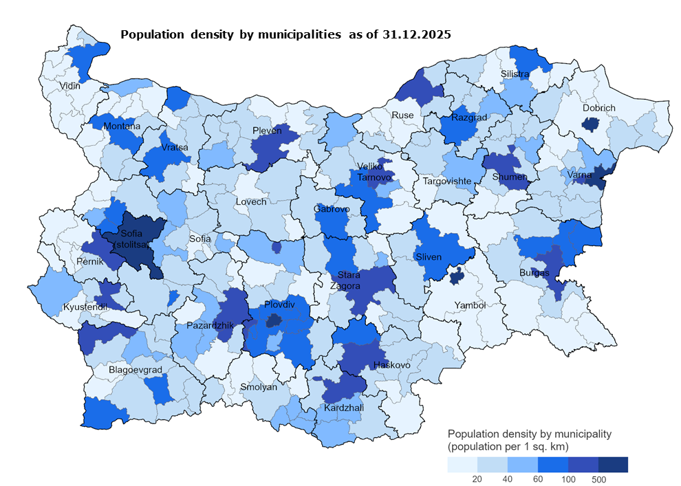
| NUTS | Districts | Total | Urbanized areas | Area excluding waters and water bodies |
|---|---|---|---|---|
| BG | Bulgaria | 57.9 | 1 210.3 | 59.0 |
| BG311 | Vidin | 22.9 | 527.1 | 23.5 |
| BG312 | Montana | 30.5 | 688.5 | 31.4 |
| BG313 | Vratsa | 39.9 | 642.4 | 40.7 |
| BG314 | Pleven | 45.8 | 844.8 | 47.4 |
| BG315 | Lovech | 26.5 | 731.2 | 26.8 |
| BG321 | Veliko Tarnovo | 42.7 | 843.1 | 43.6 |
| BG322 | Gabrovo | 45.8 | 878.3 | 46.3 |
| BG323 | Ruse | 64.4 | 1 075.3 | 66.3 |
| BG324 | Razgrad | 40.7 | 810.9 | 41.0 |
| BG325 | Silistra | 32.5 | 661.9 | 33.1 |
| BG331 | Varna | 115.4 | 1 642.3 | 117.7 |
| BG332 | Dobrich | 30.5 | 569.1 | 30.6 |
| BG333 | Shumen | 43.8 | 853.7 | 44.5 |
| BG334 | Targovishte | 34.6 | 610.3 | 35.1 |
| BG341 | Burgas | 50.6 | 1 274.5 | 51.8 |
| BG342 | Sliven | 47.5 | 958.2 | 48.4 |
| BG343 | Yambol | 31.2 | 671.9 | 31.8 |
| BG344 | Stara Zagora | 55.7 | 987.2 | 57.0 |
| BG411 | Sofia (stolitsa) | 970.5 | 5 053.3 | 1 011.2 |
| BG412 | Sofia | 31.5 | 713.1 | 31.8 |
| BG413 | Blagoevgrad | 44.2 | 1 975.8 | 44.7 |
| BG414 | Pernik | 45.4 | 876.2 | 46.0 |
| BG415 | Kyustendil | 34.2 | 992.8 | 34.6 |
| BG421 | Plovdiv | 107.1 | 1 829.9 | 110.3 |
| BG422 | Haskovo | 37.2 | 884.0 | 38.1 |
| BG423 | Pazardzhik | 49.6 | 1 486.9 | 51.0 |
| BG424 | Smolyan | 27.7 | 1 162.5 | 27.9 |
| BG425 | Kardzhali | 47.4 | 1 777.7 | 48.5 |
1 The indicator is calculated as the number of the population as of 31.12 of the reference year is divided by the area of the corresponding territorial unit in square kilometres. |
||||
| 2 Source of the population data is the current demographic statistics of NSI. | ||||
| 3 Source of the data for the areas by type of territory is the NSI's survey "Land use distribution by type of durable land use of land properties". | ||||
| Date | Name |
|---|---|
| 9.06.2027 | Territorial balance of the Republic of Bulgaria by kind of territory - 2026 |


Copyright © 2026 NSI All rights reserved