Land use distribution of the Republic of Bulgaria as of 31.12.| Contact |
|---|
| Contact organisation | National Statistical Institute |
|---|
| Contact organisation unit | ”Regional Statistics and Geographic Information” |
|---|
| Contact name | - Dimitar Popov
- Irena Dudova
|
|---|
| Contact person function | |
|---|
| Contact mail address | 2, Panayot Volov str., 1038 Sofia |
|---|
| Contact email address | |
|---|
| Contact phone number | - +359 02 9857 107
- +359 02 9857 206
|
|---|
| Contact fax number | |
|---|
| Metadata update |
|---|
| Metadata last certified | 06 July 2023 |
|---|
| Metadata last posted | 06 July 2023 |
|---|
| Metadata last update | 09 June 2025 |
|---|
| Statistical presentation |
|---|
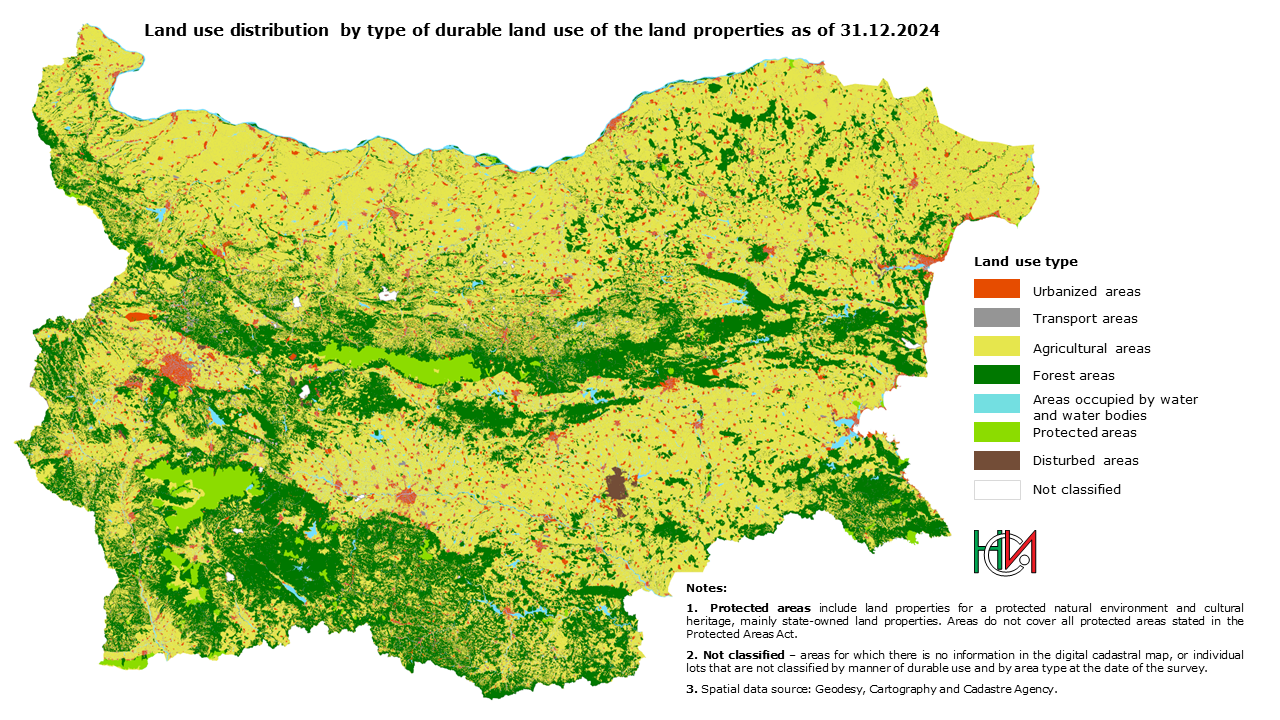
| Data description | Statistical survey on the land use distribution provides: Total area and share of the area of main land use types aggregated from the information about the land use of the land properties in the cadastral map. The data is presented on national level, by administrative-territorial units and by territorial units for statistics (NUTS). |
|---|
| Classification system | - Classification of the main land use types:
- Urbanized areas
- Transport areas
- Agricultural areas
- Forest areas
- Areas occupied by water and water bodies
- Protected areas
- Disturbed areas
- Classification of the durable land use of the land properties
- Unified Classification of Administrative-Territorial and Territorial Units (UCATTU)
- Nomenclature of territorial units for statistics (NUTS)
|
|---|
| Sector coverage | Not Applicable. The survey does not observe any socio-economic sectors. |
|---|
| Statistical concepts and definitions | The unit of observation is the land property from up-to-date cadastral map, together with the main cadastral data on the durable land use of the land property and the purpose of use of the territory, recorded in the cadastral registers. Land property - part of the territory, including areas permanently covered by water, defined by boundaries in conformity with the right of ownership. Durable land use (specific purpose of use) of the land properties shall be determined by the relevant detailed plan and recorded in the cadastral registers. The classification of the durable land use of the land properties as well the relevant codes are determined in Annex 3 of Regulation No. RD-02-20-5 of 15 December 2016 on the content, creation and maintenance of the cadastral map and cadastral registers, issued by the Minister of the Regional Development and Public Works. The area of the land property shall be assigned to the territory of one of the main classes of land resources (land use types), according to the durable land use of the land property. Main land use types: Urbanized areas include land properties for residential use, for public buildings and complexes, for greened areas and sports facilities, for resort and recreational facilities, for production and storage facilities as well as land properties with special purpose and use. Transport areas include land properties for traffic and transportation facilities and land properties for conduit facilities. Agricultural areas include land properties - crop fields, permanent crops, meadows and pastures. Forest areas include land properties - wood producing and non-wood-producing forest areas. Areas occupied by water and water bodies include land properties for watercourses, water bodies and facilities. Protected areas include land properties for protected natural environment and for cultural heritage sites. In this category, by type of durable land use, fall mainly land properties that are state owned. Disturbed areas include land properties for mineral extraction sites, land properties, occupied by industrial and municipal waste, degraded land. Not classified - This category include all areas without digital cadastral map coverage. It also includes individual land properties from the cadastral map for which there is no value for the durable land use and for the purpose of use of the territory. |
|---|
| Statistical unit | Land property. |
|---|
| Statistical population | All land properties on the territory of the country. Does not include the territory of the Republic of Bulgaria in the water area of the Danube River and the Black Sea. |
|---|
| Reference area | Territory of the Republic of Bulgaria. |
|---|
| Time coverage | 2021 - 2024 |
|---|
| Base period | Not Applicable. |
|---|
| Unit of measure |
|---|
- Square kilometers;
- Hectares;
- Percentage - %
|
| Reference period |
|---|
Data as of 31 December of the reference year. |
| Institutional mandate |
|---|
| Legal acts and other agreements | |
|---|
| Data sharing | Spatial data for the lots, used for the calculations are property of the NGCCA and cannot be provided to third parties. |
|---|
| Confidentiality |
|---|
| Confidentiality - policy | Policy on personal data in the National Statistical Institute: https://nsi.bg/en/node/17045 |
|---|
| Confidentiality - data treatment | Data are not confidential. |
|---|
| Release policy |
|---|
| Release calendar | Statistical tables on the land use distribution are updated after every survey. The present update cycle is of 1 year. The date of the release is pointed in the Release Calendar presenting the results of the statistical surveys carried out by the National Statistical Institute. |
|---|
| Release calendar access | The calendar is available on the NSI website: https://www.nsi.bg/en/node/480 |
|---|
| User access | Data is published on the NSI website, within section ‘Regional statistics and indicators for monitoring’. |
|---|
| Frequency of dissemination |
|---|
Annually. |
| Accessibility and clarity |
|---|
| News release | News releases on land use changes are published on-line with the cycle of 3 years. |
|---|
| Publications | - Regions, districts and municipalities in the Republic of Bulgaria;
- Statistical Year Book;
|
|---|
| On-line database | Statistical tables are available on INFOSTAT website under Land use distribution heading. |
|---|
| Micro-data access | Not applicable. Microdata on land property level are not provided. |
|---|
| Other | An information service could be provided by request. Rules for Dissemination of Statistical Information Products and Services. |
|---|
| Documentation on methodology | Documentation related to the survey is provided in the Land use distribution dedicated section (under Metadata and Methodology). |
|---|
| Quality documentation | NSI annually provide to Eurostat quality report on SBS data of specialised investment enterprises with information for the reference year. |
|---|
| Quality management |
|---|
| Quality assurance | Not Applicable. |
|---|
| Quality assessment | This is made in accordance with the standard criteria for assessing the quality - relevance, accuracy and reliability, timeliness, comparability and coherence. |
|---|
| Relevance |
|---|
| User needs | Main users of the statistical information from the survey are: - Ministries and state agencies;
- Municipal administrations;
- NGOs and Scientific organisations;
- Interested parties.
|
|---|
| User satisfaction | No feedback analysis. |
|---|
| Completeness | Not Applicable. |
|---|
| Accuracy and reliability |
|---|
| Overall accuracy | Statistical data are of good accuracy and reliability. |
|---|
| Sampling error | Not Applicable. Exhaustive survey. |
|---|
| Non-sampling error | The total area for which data is missing: | Year | Not classified (sq. km) | % from the total area | | 2021 | 1423.93 | 1.28 | | 2022 | 558.38 | 0.50 | | 2023 | 394.73 | 0.36 | | 2024 | 341.18 | 0.31 |
These are areas without digital cadastral map coverage, as well as individual cadastral map land parcels for which there are no values for the type of permanent use and the designation of the territory in which they fall. The information shall be presented in the category 'Not classified'. The land properties without a defined use - rocks, sands, sipes, ravines, gullies, washes and pits, as well as those with mixed or undefined permanent use are assigned to the respective land use type according to the designation of the territory in which they fall. Area of land properties without a defined use is distributed as follows: | Year | 2021 | 2022 | 2023 | 2024 |
|---|
| Land use type | sq.km | sq.km | sq.km | sq.km | | 1. Urbanised areas | 74.04 | 75.57 | 76.26 | 82.82 | | 2. Transport areas | 3.37 | 2.16 | 2.23 | 2.34 | | 3. Agricultural areas | 802.06 | 802.63 | 770.21 | 795.03 | | 4. Forest areas | 116.19 | 116.84 | 105.66 | 56.33 | | 5. Areas occupied by water and water bodies | 8.94 | 8.94 | 9.02 | 17.16 | | 6. Protected areas | 0.21 | 0.21 | 0.24 | 4.00 | | 7. Disturbed areas for rehabilitation | 8.21 | 8.22 | 8.32 | 10.97 | | Total: | 1013.03 | 1014.57 | 971.93 | 968.66 |
|
|---|
| Timeliness and punctuality |
|---|
| Timeliness | Т + 6 months. |
|---|
| Punctuality | Data are disseminated according to the Release Calendar presenting the results of the statistical surveys carried out by the National Statistical Institute. |
|---|
| Coherence and comparability |
|---|
| Comparability - geographical | Fully harmonised and comparable. |
|---|
| Comparability - over time | Partly limited, due to methodological changes applied. From 2021 NSI conducts its own calculations of areas based on spatial data from the national cadastral map. |
|---|
| Coherence - cross domain | Not applicable due to methodological differences for some of the areas. Such case is “Protected areas”, which is available also by another statistical survey carried out by NSI. https://www.nsi.bg/bg/node/2580/ |
|---|
| Coherence - internal | Not Applicable. |
|---|
| Cost and burden |
|---|
Not Applicable. |
| Data revision |
|---|
| Data revision - policy | The national policy allows revision of already published data if solid grounds for that are in place. In the particular topic, revision can be applied only for the current data series. |
|---|
| Data revision - practice | The revised data are published as soon as the revision took place. The users are informed via the official communication channels of NSI. |
|---|
| Statistical processing |
|---|
| Source data | Cadastral map and cadastral registers, provided by the National Geodesy, Cartography and Cadaster Agency (NGCCA). |
|---|
| Frequency of data collection | Annually. |
|---|
| Data collection | Copy of cadastral map is obtained yearly by the end of the reference year. |
|---|
| Data validation | Not Applicable. |
|---|
| Data compilation | The calculations of the area size of different land use types were carried out on the spatial data from the cadastral map, using GIS tools, in the BGS2005 UTM35N coordinate system. The area of the land property is assigned to the territory of one of the main classes of land resources (land use types), according to the permanent land use of the land property. |
|---|
| Adjustment | Not applicable. |
|---|
| Comment |
|---|
Please note that the shares might not sum up to 100% due to rounding. |